

Seattle Snow Forecast: Varying Chances For Flakes This Week

SEATTLE — Puget Sound’s best shot for snow of the season so far is on the doorstep, but plenty of uncertainty is left in the forecast over just how much will stick.
Much chilling temperatures are on tap this week, with afternoon highs failing to escape the 30s in Seattle on Monday and Tuesday, and overnight lows landing right around freezing. Conditions should be cold enough for lowland snow several times in the days ahead, but a few variables will make all the difference in how wintry the weather turns — from very cold rain to a bounty of snow.
Here’s some of the latest thinking from the National Weather Service for Tuesday and Wednesday:
“With cooler air in place, especially if the current timing holds true, expect to see some light snow to fall at onset with the moisture running ahead of the approaching warm front. Southerly low-level winds should bring a slight bump in snow levels and preclude much in the way of snow accumulations south of around Tacoma Meanwhile, confidence is lower for around Seattle, where the timing of the warm southerly flow arriving and the moisture leads to a somewhat tricky forecast where a few degrees in the temperature profile is all the difference between a few inches of accumulating snow and a cold 35 degree rain.The most likely scenario for accumulating lowland snow during this time would be during periods of heavier precipitation, where enough cold air is dragged down to the surface.Snow levels are then expected to drop back down below 1000 feet by Wednesday afternoon. With colder air filtering in Wednesday the threat of accumulating lowland snow increases and will remain.” (NWS Seattle)
Forecasters expect chances of precipitation will build Tuesday afternoon and evening, opening the door for accumulating snowfall in much of the lowlands before transitioning to rain. Another good chance for snow will arrive late Wednesday into early Thursday, and cold temperatures will linger in the forecast into the weekend.
The latest snowfall probabilities vary greatly by region and appear best in the Cascade foothills, areas north of Seattle and along portions of the Kitsap and Olympic Peninsulas. The odds for snow are much lower around Tacoma and points south.
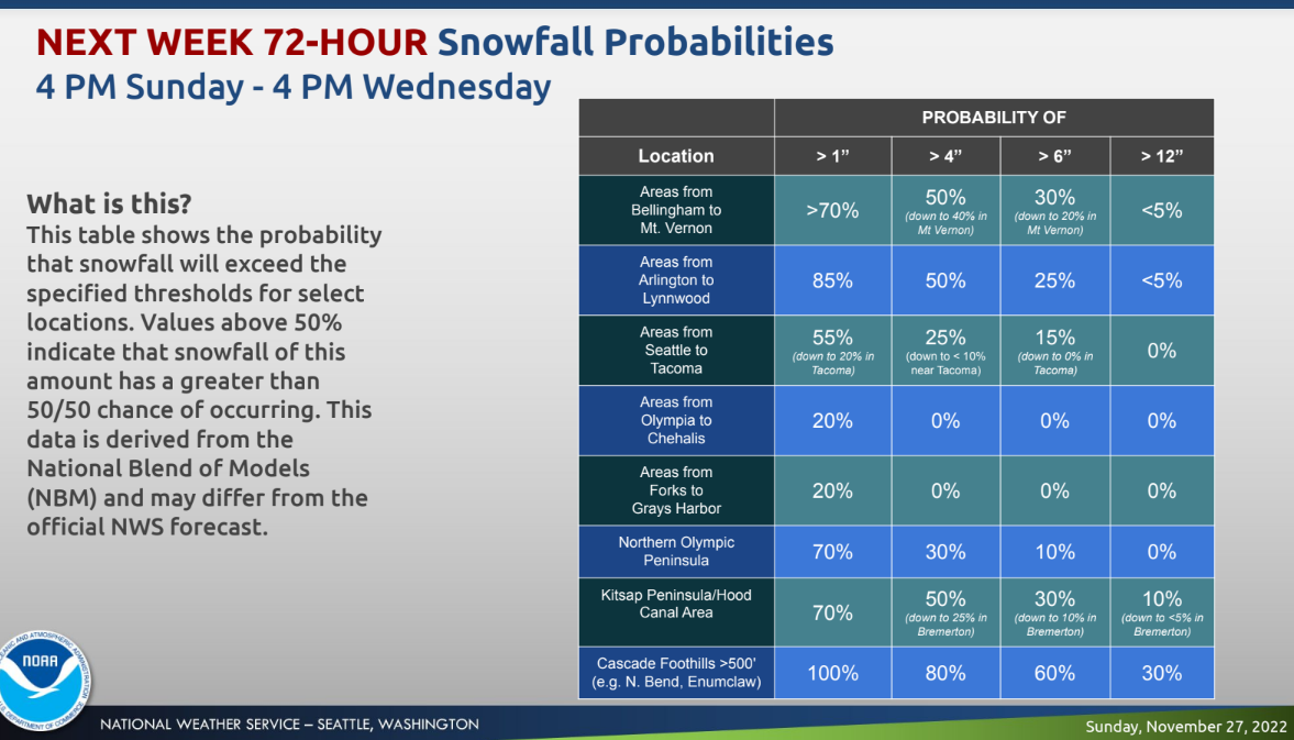 (NWS Seattle)
Forecast models continue to paint vastly different pictures for the Seattle metro, and little fluctuations will make a big impact on how the system shakes out across the region.
I just don’t think it’s going to get quite cold enough. The UW model (based off the GFS) is notorious at overdoing the cold. And in this case, that could mean the difference between 36-degree rain & 34-degree slushy snow.
— Seattle Weather Blog (@KSeattleWeather) November 28, 2022
As for the mountains, Snoqualmie and Stevens passes may pick up another two feet of snow between Tuesday afternoon and Thursday morning, adding on to an early-season boon for the Cascades. At Mount Rainier, Paradise could pick up even more.
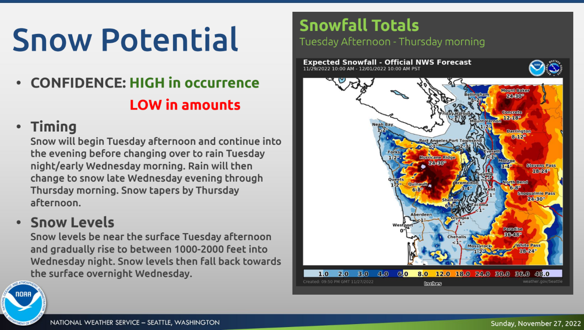 (NWS Seattle)
With frigid temperatures in place for the foreseeable future, state transportation officials are reminding drivers to plan ahead for potentially slick morning and evening commutes through the work week.
Good morning and Happy Monday! This week will be a doozy, weather-wise. Please make sure before you head out in the mornings to check that your car is properly winterized and also adjust your speed for conditions. 🌨️ Winter driving tips: https://t.co/etN0W0vvgG 🏔️@NWSSeattle pic.twitter.com/AvH1BnqG6X
— WSDOT Traffic (@wsdot_traffic) November 28, 2022